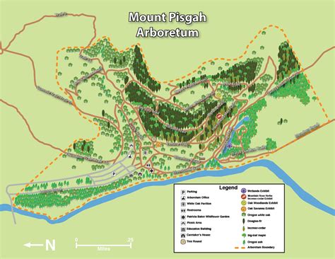
Mount Pisgah Arboretum and the surrounding Buford Park offer an extensive network of trails across diverse habitats, including riparian zones, wetlands, oak savanna, and conifer forests. The improved accessibility route, inspired by accepted trail accessibility standards, provides a Barrier Free Loop across multiple trails with gradual elevation gains, wide paths, and regular resting spots. The loop traverses through the Arboretum’s signature landscapes, aiming to be welcoming for visitors of varying abilities while preserving the natural character of the area.
Trail highlights and accessibility overview
The Improved Access Loop is designed to be wider and to include regular resting points, with some sections featuring minimal elevation gain. All-terrain track chairs are recommended for lower parts of Buford Trail along the Barrier Free Loop, though some segments may be narrow or require careful navigation. The loop goes through a variety of habitats, including riparian areas, wetlands, and oak savanna, making it a versatile route for first-time visitors and seasoned hikers alike.
The Buford Trail ascends the hillside at the Arboretum, skirting the large oak savanna before entering the conifer forest. At the start, visitors can access the Tree Round Exhibit and the Oak Savanna Exhibit, and at the top, the Oak Woodlands Exhibit. The Creek Trails run along the Arboretum’s main seasonal creek, providing opportunities to view wildflowers in spring and birds year-round. Bridges connect the creek’s sides, and the trail begins near the White Oak Pavilion and adjacent picnic area.
The Hillside Trail traverses a forested slope with conifers and hardwoods, offering shade and frequent sightings of water-loving plants and woodpeckers. Cross Slope is minimal to the Incense-cedar Exhibit, and all-terrain track chairs are not recommended past that point due to narrowing paths on the east side.
The Incense-cedar Trail traverses hillside groves of incense-cedars, with shade, spring wildflowers such as calypso orchids, and a largely flat profile until the Incense-cedar Exhibit where elevation gains and cross-slopes appear. The Jette Trail provides views of wildflower meadows and mixed forests, connecting to conifer stands on the plateau. It switches back from Quarry Road (Trail 5) to reach the plateau and links with the Incense-cedar Trail; the lower portion’s width is about 36 inches with a mostly even slope, and some protruding roots present an obstacle.
The Lower Plateau Trail is wide and relatively flat, meandering through grassland, coniferous forest, and oak woodland, with the southern section showcasing the oak savanna near the Oak Woodlands Exhibit. It connects to the Upper Plateau Trail, Jette Trail, Oak Savanna Trail, and Trail 35. The Meadow Road is a main route through the lowlands, passing through a large oak savanna and following the Coast Fork of the Willamette River to the Howard Buford Recreation Area’s South Bottomlands. Shade is limited along Meadow Road, which may be hot in summer, and there are multiple bridges which can present obstacle transitions between trail and bridge surfaces.
The Oak Savanna Trail travels through grassy and oak-filled landscapes, crossing multiple seasonal streams, and is a good place to find lizards in summer and wildflowers in spring. The Pond Lily Trail runs along the wetlands’ northeastern portion, with access points near Meadow Road and Quarry Road; connections to the Quarry Road are accessible via Adkison Bridge with varying cross-slopes. The Quarry Road (Trail 5) passes through oak savanna habitats by a historic barn, offering wide avenues for exploration. The Riverbank Trail follows the Coast Fork of the Willamette River, beginning near the lower Arboretum entrance, with a steep initial descent into the Patricia Baker Wildflower Garden and a largely flat, packed gravel surface thereafter. There are four benches along the Riverbank Trail, but surface conditions can include loose gravel and occasional steeper sections near the river.
Other notable routes include the Upper Plateau Trail, which offers expansive views of grasslands and forest edges, and the Water Garden Trail, which winds through a moist spring meadow and provides views of the wetlands from the Wetlands Exhibit and Adkison Bridge. The Zig-zag Trail travels through coniferous and mixed forest, crossing multiple bridges and offering standout native and spring wildflower viewing. Together, these trails contribute to nearly 30 miles of winding paths across Buford Park and Mt. Pisgah, maintained by volunteers and donors with support from Friends of Buford Park and Mt. Pisgah.
Facilities, access, and practical details
Parking options include three lots: two on the west side off Seavey Loop Road and one on the east side off Ridgeway Road. Parking typically requires a daily fee or an annual Lane County Parks pass. Donating to Friends of Buford Park & Mt. Pisgah at $50 or more can grant an annual parking pass valid at Lane County parks for the entire year. Real-time conditions are available via Lane County Parks webcams, helping visitors plan outdoor trips.
Hours of operation for the park are dawn till dusk year round. The Arboretum and HBRA offer numerous opportunities for hiking, wildlife viewing, education programs, events, and volunteer opportunities. The White Oak Pavilion provides a large event space with views of the oak savanna.
Trail etiquette emphasizes staying on designated paths, yielding to horses, keeping dogs under control, and packing out trash. Restoration areas and wildlife should be respected to ensure long-term enjoyment. Large groups are encouraged to make reservations in advance of visits.
Suggested routes and highlights
- The Thompson Slough Loop - 1.5 miles: perimeter loop along wetlands near Thompson Creek Slough and a fork of the Willamette River, ideal for fall color viewing.
- Mt. Pisgah Summit Hike - 3.5 miles: start at the North Bottom Lands parking lot for a brisk ascent to the summit with valley views.
- Dery's South Summit & Beistel's East Summit Loop - 4.8 miles: includes Mount Pisgah, Beistel's East Summit, with steep sections but rewarding vistas.
Accessibility options include two all-terrain track chairs available for free reservation via David’s Chair. The network supports equestrian use and dog-friendly areas, and there are several scenic viewpoints across the plateau and summit areas.
Getting there and practical notes
The Mount Pisgah area lies just east of Eugene, Oregon, at the confluence of the Middle Fork and Coast Fork of the Willamette River. The summit rises about 1,561 feet with an elevation gain that rewards visitors with expansive valley and, on clear days, Diamond Peak visibility. There are multiple trailheads: Main Trailhead (West side), North Trailhead, and East Trailhead, each offering variations and access suitable for hikers, equestrians, and visitors with mobility considerations.
Current park alerts may include parking lot improvements and occasional closures; all trails remain open, and visitors are advised to use North Bottomlands or East Trailheads for easier access when the main lot is under construction. The Arboretum sits within a larger 2,200-acre Howard Buford Recreation Area, offering nearly 30 miles of trails and a broader spectrum of habitats beyond the Arboretum proper.
For visitors seeking a conservation-focused experience, Friends of Buford Park & Mt. Pisgah organizes volunteer opportunities to maintain paths, improve accessibility, and steward the landscape. An annual Lane County Parking Pass can be obtained with a donation, enabling parking across Lane County parks for the year, facilitating easier access for weekend explorers and long-time supporters alike.
Practical notes and care tips
Trail surfaces vary from wide packed gravel to bark mulch and natural surface, with some cross-slopes and occasional roots or uneven segments. While many trails are mostly flat or gently rolling, some routes-especially steeper sections on Mt. Pisgah Summit approaches and the steeper parts of Trail 35-require extra care. Visitors are encouraged to plan ahead, check conditions, and use appropriate footwear and gear for variable terrain.